
Search Buncombe Streets by Address
A Buncombe street search works best as a chain of records, not as a claim about every person at an address. Start with the county tax result to collect the situs address, PIN, and listed owner. Then use the same parcel in the map, where deed and plat references can connect the street result to recorded documents. A voter profile, when a specific person is already known, is a separate confirmation route. Historic street listings help with an earlier household, but they need the year and any numbering changes kept in view.
- Open Buncombe County Tax Lookup, choose Address, and search the street phrase with and without a number. Review every result page and export when the result set is long.
- Record each unique PIN, situs, and listed owner. A PIN identifies a parcel, so it is more reliable for removing duplicate rows than an owner name.
- Open the parcel in Buncomap. Turn on Property, Address, and Street Centerline before using Identify or Select Multiple Features along the chosen segment.
- Copy deed and plat book or page references, then search the owner and grantor names in the Register of Deeds index by name, date range, and index type.
- For a past address, compare the date with Asheville street and reverse listings at Pack Special Collections, then use neighboring entries and maps when an old number fails.
Use a consistent spelling in notes, but retain the spelling returned by each office. Directional variants matter. A search for a north, south, east, or west version can produce a different result set. The inspected Asher Lane result also ran across five pages, which is why the first row is not a whole-street inventory.
Buncombe Tax Lookup by Street
The tax portal is the address entry point for the Buncombe street directory because the deed index is a name search, not an address search. Tax Lookup offers All Criteria, Owner Name, Address, Parcel ID, and Bill Number. The search phrase needs at least three characters. Its advanced controls include All Bills or Unpaid Bills and real-estate, business-personal-property, and individual-personal-property bill types. The results page can be exported and may show a thumbnail, PIN, situs, owner names, amount due, and a View Parcel link.
| Tax Lookup field | Input type | Use along a street | Result caution |
|---|---|---|---|
| Search criteria | Dropdown | Select Address for a street phrase | It is not a resident filter |
| Search phrase | Text | Use a street name, number, or PIN | Three characters minimum |
| Bill Status | Filter | Keep the desired bill set visible | Tax status is not a legal certificate |
| Bill Type | Filter | Limit the category when needed | Do not infer occupancy from it |
| Export Results | Action | Review a multi-page street result | Deduplicate by PIN |
Land information is billed as of January 1. The county warns that Tax Lookup is not certification that taxes are paid or due and can omit some not-yet-billed Discovery or Deferral bills. A parcel card can add assessment, building, land, sketch, exemption, and history details, but those are assessment clues. A listed owner is not automatically the person currently present at the situs address.
Note: Record the search date because the tax and assessment display can change after an update or correction.
Map a Buncombe Street Parcel
Buncomap Online Help documents the map tools used to inspect a street visually. Search by PINN, street name, or owner name, select a parcel, and use the property-card, deed, and plat links in the map result. For a short block face, Select Multiple Features draws a rectangle around several parcels. Buffer is useful for a consistent visual radius, but it is not a legal boundary.
The Buncombe street directory gains useful context from the ZIP Code, Incorporated Areas, County Boundary, township, ETJ, zoning, school, fire, flood, sewer, and contour layers. They can explain why nearby addresses with the same postal city receive different public services. They do not establish a person's presence, and the county says its GIS is reference data rather than survey-grade evidence.
| Buncomap field or tool | Street use | Local limit |
|---|---|---|
| PINN, Street Name, or Owner Name | Open a parcel or road-area result | Choose one of the three primary search keys |
| Deed or Plat Book/Page | Reconnect a parcel to recorded references | Requires the book and page already identified |
| Subdivision or Neighborhood and City | Refine a map report | Not a household or occupancy filter |
| Select Multiple Features and Buffer | Inspect several parcels or a visual radius | Neither creates a legal boundary |
| Property, Address, Street Centerline, and ZIP layers | Compare parcel and postal context | Map data is not survey grade |
Use the official Buncomap help page before working a street segment; the captured controls show the map's selection and parcel-link workflow.
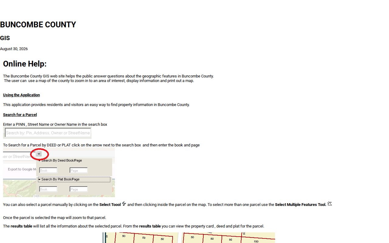
The screen supports a repeatable map pass: establish the road and address layers, select parcels, and carry the PINs back to the tax and deed records. Buncomap refreshes on weekday mornings, so an inspection date belongs with any saved findings.
Buncombe Street Record Chain
Address-keyed sources answer different questions. Tax Lookup gives the current assessment view. Buncomap puts a parcel in place and exposes map layers. The Register of Deeds supplies the recorded transfer trail, while public permits can date work at a city property. Historic reverse listings add an earlier street-address connection. Read them together, because no single source is a complete street directory of every household.
| Address record | Buncombe keeper | Street-level value | Access route |
|---|---|---|---|
| Tax Lookup | Tax Assessment and Collections | PIN, situs, owner, bill details, parcel link | Online name, address, PIN, or bill search |
| Buncomap parcel layer | GIS and Land Records | Parcel geometry, owner linkage, ZIP, districts, and road layer | Online map tools and layers |
| Recorded deed or plat | Register of Deeds | Parties, dates, legal description, book and page | Name index, counter, or mail copy request |
| City permit | Asheville Development Services | Address or PIN, status, inspections, and attachments when public | Citizen Access or a records request |
| Historic street listing | Pack Special Collections | Earlier name-to-address relationship | Directory shelves and digitized volumes |
Land Records and the Register of Deeds also provide counter and request channels when a portal does not expose an image. The county's Land Records Research Request Form accepts a subject PIN or property address and a description of the existing map or record sought. It can be sent by email, mail, or drop-off, and the form says a mapper will respond within five to ten business days.
Turn a Buncombe PIN Into Deeds
A PIN connects a street result to a parcel, but a deed chain begins with people or entities. Take the current listed owner from the parcel and open the Buncombe Register of Deeds Quick Name Search. The form provides Last or Firm Name, First Name, Side, Name Type, Index Type, a start and end date, sort controls, and autocomplete. Search variants for initials, punctuation, trusts, estates, and organization names before deciding that two names are different people.
Find the current buyer as a grantee, then note the seller, recording date, instrument type, book and page or document reference, legal description, and plat reference. Search that seller as an earlier grantee and repeat. The legal description is often a better continuity check than the street number when names or numbering change. The Register of Deeds does not perform title searches or give legal advice, so a complete title or lien conclusion requires qualified help.
Use the Quick Name Search before asking the counter for a document; its result flow exposes indexed party, role, index type, recording date, reference, and image link fields.
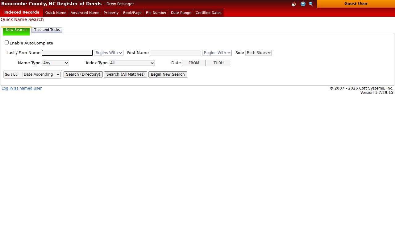
An image may require a different access step, but the recorded date and book or document reference still make a counter or mail request precise. Certified real-estate copies cost $5 for the first page and $2 for each additional page; uncertified copies cost $0.25 per page.
Buncombe Deed Series Have Dates
The county's certified-date screen is a useful numbers check for a Buncombe street directory search. It separates pre-1995 deeds, corporations, and assumed names beginning October 13, 1783 from consolidated real property beginning January 1, 1995. Pre-1995 deeds of trust run from August 21, 1928 to January 1, 1995. Maps and plats begin at January 1, 1900 in the displayed series. Those start points describe distinct index series, not one blanket promise that every land record begins on the same date.
A missing deed-of-trust satisfaction can have a local explanation. Before February 3, 1997, requests for notice and cancellations of deeds of trust were made by marginal entry and may not be indexed. Check the instrument, book, and counter record rather than assuming a missing web hit resolves the question.
The Register of Deeds certified-date page shows why a street research log should name the series as well as the date range.
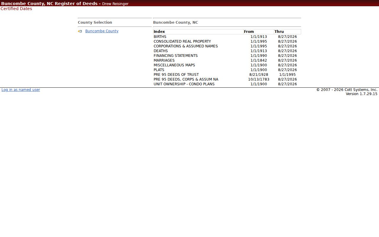
The display makes the 1783, 1928, and 1995 breakpoints visible before a name search begins, helping avoid an overbroad statement about online coverage.
Buncombe Address Terms Matter
Several labels can look alike in a search result but mean different things. Keep them separate in notes. That simple discipline prevents a mailing destination from being copied as a physical parcel location or a map outline from being treated as the final legal description.
- Parcel or PIN
- The county identifier for a land parcel. It is the best key for grouping duplicate tax results that list more than one owner.
- Situs address
- The physical location assigned to the parcel. It can carry an Asheville postal label even when the parcel is outside Asheville city limits.
- Plat
- A recorded map that can show lots, blocks, subdivision layout, easements, and a plat book or page reference.
- Criss-cross directory
- A reverse street listing that starts with an address and points to a name in a particular directory year.
An owner mailing address may be a PO box or a place outside Buncombe County. It can be a useful correspondence clue, but it is not proof that the owner occupies the parcel. A deed's legal description, whether lot and block, subdivision, metes and bounds, or a prior deed and plat reference, is the location language that can survive a changed street number.
Buncombe Streets Before 1930
Historic Asheville street work has a known numbering trap. Pack Special Collections' house-history guidance warns that early house numbers changed as new houses were built, especially before 1930. The 1883-84 Asheville directory introduction also says many streets were unnamed and exact locations could not always be assigned. A missing modern number therefore does not show that a household or building was absent.
Search the street without the number, compare neighboring entries, and use a deed legal description or plat reference to bridge the gap. Pack's house-history route also points to Sanborn maps from the 1885-1950 period and Asheville panoramic maps from 1891 and 1912. Those sources provide street context; they are not a substitute for a survey or recorded instrument.
For the full historical shelf, Pack's Asheville directory holdings and digitized volumes are described on the Buncombe city directory page.
Note: Preserve the directory year with every historic address because the same number can refer to a different location after renumbering.
Buncombe Permits by Address
For a property inside Asheville, the Citizen Access portal offers Address and Parcel Information modes, street-number and street-name inputs, and a property-information tab. Its public records can include a record number, permit or application type, status, parcel, address, inspections, conditions, related records, and attachments when the particular result exposes them. A permit can help date construction or alteration, but it does not establish a transfer date or current presence.
Asheville describes the database as access to current and completed development activities. Pre-2019 city records have a documented paper gap, so a missing portal result can call for a detailed city request instead of a conclusion that no record exists. County permit summaries and historical archive links are additional routes, but no unified countywide permit search with a confirmed field set was located.
Buncombe ZIP Layers Along Streets
Buncomap's ZIP Code, Incorporated Areas, county boundary, and ETJ layers help diagnose a common local mismatch. An Asheville postal address can be outside Asheville city limits, while Arden, Candler, Weaverville, Black Mountain, Fairview, Fletcher, Leicester, Swannanoa, Barnardsville, and other post-office names can appear in a county street search. A postal city is not the same thing as municipal jurisdiction.
Use ZIP and jurisdiction layers to explain the record path, then use the parcel's situs and legal description for the property connection. A city address can lead to Asheville permit records; an unincorporated location may require county offices instead. The ZIP layer is a geography aid, not a ZIP-wide resident roster.
Limits of Buncombe Street Records
The Buncombe street directory cannot produce a complete list of everyone at an address. Tax, deed, and plat records show property relationships. A named voter profile is a person-by-person tool, not a block browse, and protected voter addresses can be withheld. Utility-customer identifying information is protected by N.C. G.S. 132-1.14, and DMV address information is not an open street source. Permit parties and deed parties show a connection to a record, not proof of presence.
Lawful use. Buncombe address records are for personal, lawful research and civic record review. Do not use them to monitor, harass, intimidate, or harm anyone; North Carolina stalking and cyberstalking laws can apply to misuse.
North Carolina's Address Confidentiality Program can protect a qualifying participant's physical address, and the voter statute provides a protected-address process. A current map point, an old directory, and a tax row are all limited records. When a question concerns a specific public record, ask the custodian for that existing item rather than asking an office to construct a new street roster.
Buncombe Street Counter Options
Online work has useful fallback channels. The Register of Deeds Public Record Search Room at 205 College Street is open weekdays from 8 a.m. to 5 p.m. for public records. Real-estate copy requests may be made by mail with the county form and payment. Land Records and Tax staff can handle a specific PIN, address, map, or card question, and the county public-record request route is for identifiable existing records, not new analysis or a list created from incomplete clues.
For historic street evidence, Pack Memorial Library Special Collections has Asheville city directories, maps, newspapers on microfiche, and house-history resources. Older assessor books and tax scrolls are connected through the Record Archive. These alternate channels matter when a current portal lacks an image, a series is not digitized, or a pre-1930 number no longer matches the modern street.
Note: Bring the PIN, the street spelling, a date range, and any deed or plat reference when asking for an existing Buncombe record.